Labrador Sea
Saturday, July 12th 1200 EST (56o 22’N, 52o53’W): Labrador Sea
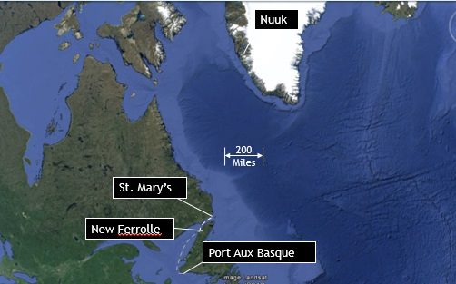
Last Wednesday evening we were in a thick fog in the Strait of Belle Isle, looking for a spot to refuel. Crew member Dave Johanson, whose parents have sailed the coast of Labrador in years past, recalled that his mother had recommended the nearby Port of Saint Mary’s. His co-watchman of the hour, Pete Fasoldt, entered a string of waypoints to guide us in through the fog and, as sunset approached, we began following an eight-mile path threading its way through the contours of shallow waters and yellow patches of dry land displayed on the chart plotter. As we motored inward, the temperature rose, leaving the fog behind and revealing an archipelago of closely packed small coastal islands. As typical of the northeast coasts, these islands are solid granite, with rounded shapes, like large turtles, presumably ground smooth by glaciers eons ago. Most had no trees, but were capped with lichen and bushes where the elevation was sufficiently above the shoreline to offer some isolation from wind and waves. Icebergs had found their way into the channels and were hard aground, melting in shallow waters. Even if we hadn’t spent the day in it, the lifting of the fog would have been an inspirational sight, with the beauty of the island, the ice, the setting sun, and the gibbous moon behind us as we motored towards St. Mary’s. We arrived shortly after sunset and spent a quiet night tied up behind a fishing boat at the commercial dock.
In the morning, Peter got himself up and disappeared into town, arriving back around 0700 to announce to the rest of us, still in bed, that fuel would be available after 0900 and there was at least one grocery store nearby. As the fishing boats attended to their gear, we took on 60 gallons of water, filled our five five-gallon jerry cans with diesel and secured them on deck, and topped off our main tanks, all with the friendly help of the owner of the facility. The main tank took 130 liters (33 Gallons) of diesel, at $1.40 Canadian per liter. Given that we had run the engine for 44 hours since our last refueling, our consumption rate is approximately ¾ gallon per hour. These statistics raise the question of why the fuel gauge was reading half empty for a 110 gallon tank, but reassure us that the consumption rate is more in line with what is expected. Meanwhile, while the refueling operation was going on, Peter made a quick run to the grocery and by 10:00 we were motoring back out between the islands, with full fuel, water and fresh groceries, and the next stop being Nuuk Greenland.
The days that have followed have been hard to keep track of, given the irregularity of our watch and sleep schedule, but we have had better weather than we could have hoped for. The day we left St. Mary’s was a perfect day of following wind, clear skies, and icebergs safely showing off their variety of sizes and shapes, like ship sightings in Penobscot Bay. And last night, although without wind, had a beauty of its own as we motored with calm seas, clear sky, a full moon casting shadows, and a horizon ahead that never lost the faint red glow of twilight.
Today there is still little wind, so we continue to consume diesel as we motor towards our destination at around 5 knots. For those of you unfamiliar with knots, it refers to nautical miles per hour. A nautical mile is approximately 1.1 statue mile. More logically, a nautical mile is equivalent to one minute of latitude (or 60 nautical miles to a degree of latitude). This relationship to the circumference of the earth makes it easy to compute distance when dealing with nautical charts. For example, we are currently a little north of latitude 56 degrees, with Nuuk being nearly due north of us, at latitude 64. That means we have eight degrees, or 480 nautical miles north (8 x 60 per degree) left to go. 480 nautical miles is 528 statute miles. In a car, that would not be too bad, but at 5 knots, it’s like jogging at a 10 minute per mile pace from Birmingham AL to Cincinnati, Ohio. In any case, if you want to know where we are now, pick an isolated spot out in the middle of the Labrador Sea (Mer du Labrador) and, if it weren’t for our GPS, we wouldn’t know the difference.