AIS
Saturday, Sept 11, 2021
Latitude 42o 07’ N
Longitude 08o 51’ W
Monte-Real Club de Yates
Baiona, Spain
AIS: Automatic Identification System
An Automatic Identification System on board is nearly indispensable for sailing anywhere there is traffic about, especially at night or in a fog. It turns traffic separation into a video game since other vessels so equipped are displayed as triangles on the chart plotter. Clicking on a triangle displays the name, speed and dimension of the vessel and projects how close you’ll pass and in how many minutes.
Having other vessels see you on their screen and knowing your name has helped more than once over the 7 years I’ve had the system. “Lillian B, turn left ninety degrees,” came a call at night back in 2017 as we approached the docking facilities in a light rain at night along the Fear River in Wilmington, NC. Dazzled by the lights on a cargo ship combined with those of the city beyond, we were unknowingly about to interfere with a docking operation. We didn’t need to know which boat it was calling; clearly they were talking to us. We turned left.
Knowing how close you are coming to another vessel and how long before the closes point of approach is a key safety feature, especially when they are closing fast. As we approached the NW coast of Spain, we were crossing the shipping lanes of cargo ships rounding the corner. Just before sunset last Monday, the chart plotter was filled with over a dozen AIS triangles, each one representing a massive cargo ship.
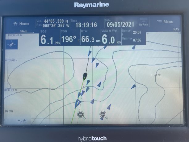
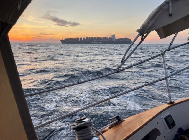
Three of them, bearing down on our stern, were less than ten miles behind, which at their speed left less than 15 minutes before their closest approach. Clicking on the screen to cycle through the data for each triangle, the one of most concern was the Prague Express, projected to pass within a quarter mile plus or minus ten percent. That might sound like plenty of clearance, but the length of the Prague Express herself was listed as 0.2 miles (336 m). That meant she would pass us within less than ½ her length. Too close for my comfort.
We hailed them on the VHF radio. “Prague Express, Prague Express, sailing vessel Lillian B, Over.” The reply came right back, “Lillian B, this is the Prague Express, Over” “Yes sir, we are the sailing vessel Lillian B, ten miles off your bow. Would you like us to head to starboard or maintain course for clearance?” (Since we were close on the wind, it would have required a tack on our part to turn left, but if they had requested a left turn, we’d have been glad to oblige.) The Prague Express replied, “Lillian B, maintain your heading, we will alter course and pass you to starboard, Over.” “Thank you, sir. Lillian B. Out.’
This was the second time since leaving Rockport ME that we’ve radioed a cargo ship to coordinate our separation. In both cases, the ships accommodated us by altering course. Even without AIS, these commercial ships would no doubt see us on radar and avoid us, but it’s reassuring to be able to communicate. More than once, we’ve altered and maintained course based on the AIS to clearly indicate to an approaching vessel how we intend to steer clear, without having to resort to using the radio. And, in the case of the ship docking on the Fear River, it enabled us interact professionally with commercial vessels and avoid creating a nuisance, if not an accident.
P.S. For anyone who wants to track us, there are several Apps, like Marine Traffic, that enable tracking the position of ships around the world based on AIS. For us, search for “Lillian B.” Reportedly, Marine Traffic, only allows one to track Lillian B when she’s in range of land-based towers, but others Apps can track her via satellite when she is off shore. If anyone knows of a better App please let me know via [email protected] and eventually I’ll include it in the blog.