Arrival in Rangiroa
Thursday May 27, 2004
At Anchor inside the atoll of Rangiroa, Tuamotus
S 14o 57.938 W 147o 38.458
By virtual of fortunate winds, we approached the atoll of Rangiroa on the morning of Thursday, May 27th. This arrival time was precisely what we had hoped for, since mid day offers the best light for spotting the low lying atoll and negotiating the pass through the ring. Despite the marvel of satellite navigation, the human eye remains the most reliable means of close-in navigation. The GPS can tell you where you are on the globe to within a matter of feet, but it can’t tell you what is there with you. This fact is emphasized by the disclaimers on even the most “current” charts such as our National Imaging and Mapping Agency (NIMA) chart number 83020:
South Pacific Ocean, Iles Marquises
From French surveys between 1953 and 1964
Shoreline and topography from French surveys in 1881 and 1882, Navigational aids and hazards corrected to 1976
CAUTION: The charted positions of the islands are not to be relied upon. Differences in latitude and longitude may exist between this and other charts of the area; therefore, the transfer of positions from one chart to another should be done by bearings and distances.
In practice, the charts have thus far been very accurate, and we have supplemented them with invaluable cruising guides such as “Charlies Charts” written by those that have come before us. These cruising guides include verified GPS waypoints and navigational advice such as, “a good landmark on the corner of the reef on the eastern side of the pass is a tall, white concrete tower which is readily visible. “
As we approach within 25 miles of the expected position of Rangiroa, we switch on the radar to check for an echo. Six miles out, there is still no radar return, but a line of palm trees is starting to appear on the horizon. Rangiroa is the second largest atoll in the world, having a circumference of approximately 100 miles and the line of trees extended across the horizon. At its thickest point, the ring of the atoll is less than 2000 feet of sand and coral separating the large lagoon from the pounding ocean. The height of the atoll is little more than that of the palms sprouting from the sand and shells.
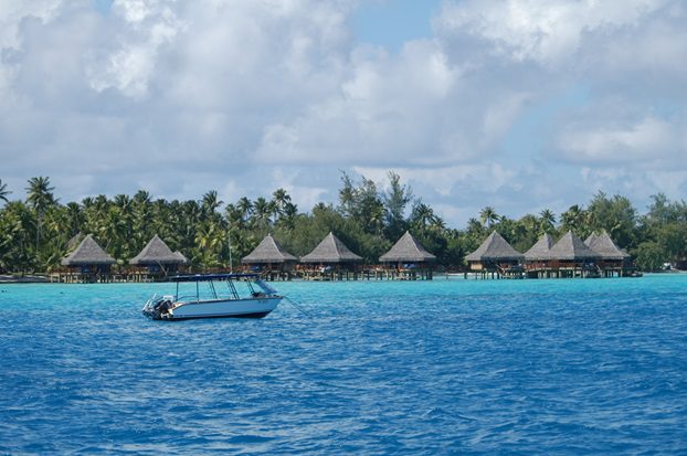
Within 2 miles of the atoll, we furl the sails and start the engine. I do a blind call on the VHF radio asking for advice on the pass. My primary question is the direction and strength of any tidal currents running through the pass. I make the call in English and then high school French: “Good Morning. This is the sailing vessel Lillian B. I am looking for advice on the Tiputa Pass, Over.” No response. “Bon Jour, C’est le voilier Lillian B., je cherche une recommendation pour la passe Tiputa.” After the second call, the sailboat “Autumn Mist” responds in easy-to-comprehend American English, saying they had just left the pass an hour earlier and that the water was smooth, running in at three knots. Three knots being acceptable for Lillian, with a top speed of 5-7 knots, we proceed. With the extra caution of first timers, Peter and I keep rechecking the charts, GPS, and advice from “Charlie” to make sure everything is consistent. There are nearly 130 channels into the lagoon from the Pacific, but only two of them are deep enough for Lillian to negotiate. This particular pass, Tiputa, is very well marked with buoys marking the coral and a set of two tall towers that, when aligned, indicate the centerline of the channel. Looking ahead through the pass is like looking back out into the Pacific, except the waters are calm. At 17 nautical miles away, the other side of the atoll is hidden well below the horizon. Once through the pass, the waters around us suddenly radiate the brilliant blues of a coral reef, reminiscent of those in the Florida Keys. Continuing to follow Charlie’s advice, we make a wide turn towards the dozen or so anchored sailboats spread out along a mile of white sand beach. As we approach the yachts, we see a familiar boat, Cat’s Paw anchored approximately 400 yards off the tropical resort hotel of Kia Ora (www.hotelkiaora.com ) with its thatched bungalows on stilts out in the lagoon. We motor close to Cat’s Paw to shout hello and then drop anchor nearby. We switch off the motor, turn off the electronics, and Lillian takes her place as if part of a travel postcard.